COLUMBIA, S.C.
— As the
Department of Defense prepares to retire the Defense Meteorological Satellite Program (DMSP)
on
July 31
, concerns are rising about how the change could impact
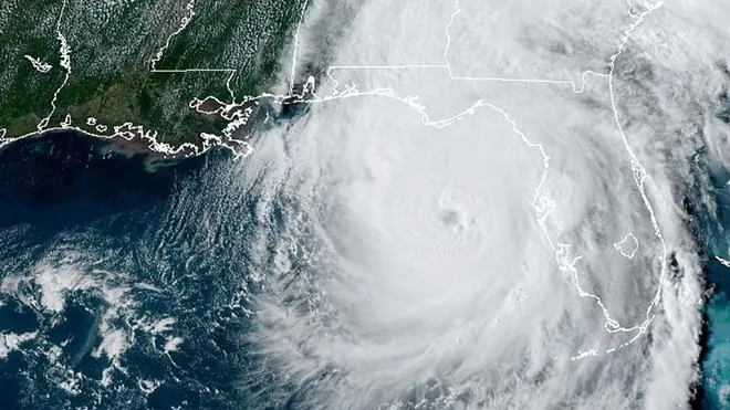
hurricane forecasting for South Carolina
during what’s projected to be an above-average storm season. But experts say the Palmetto State’s forecasting tools remain strong — with or without the aging satellite system.
What Is the DMSP — And Why Is It Ending Now?
Launched in the 1960s, the
DMSP has provided decades of environmental data
, capturing detailed weather imagery and storm structure insights using microwave sensor instruments. These satellites orbited Earth 14 times a day, helping forecasters track hurricanes, identify storm centers, and anticipate intensification.
However, most of these satellites — launched between 1999 and 2009 — have already far exceeded their five-year intended lifespan. Their
termination was first proposed in 2015
, with the final phaseout extended to this July after a
NASA-requested delay
.
The shutdown comes amid
NOAA staff reductions
tied to federal budget cuts under the Trump administration and an effort to
modernize national weather infrastructure
due to growing cybersecurity risks.
Will South Carolina’s Hurricane Forecasts Be Less Accurate?
According to NOAA and meteorologists interviewed by the
Island Packet
, the answer is
no
.
“The DMSP satellite program is a single dataset in a robust suite of hurricane forecasting and modeling tools,” said NOAA spokesperson
John Bateman
. “NOAA’s data sources are fully capable of providing a complete suite of cutting-edge data and models that ensure gold-standard weather forecasting.”
Forecasting tools used to monitor hurricanes along
South Carolina’s vulnerable Lowcountry coast
include:
-
Hurricane Hunter aircraft
-
GOES and JPSS satellites
-
Advanced Technology Microwave Sounder (ATMS)
-
Ground radar, weather balloons, and buoys
-
Dropsondes and upper-air observations
NOAA reports that
hurricane track forecasting has improved 75%
since Hurricane Andrew in 1992, with intensity forecasting improving by 50%. Officials believe this progress will continue with newer instruments now in operation.
What’s Replacing the Satellite Program?
Several advanced systems are already in place to fill any potential data gaps:
-
Weather System Follow-On – Microwave (WSF-M)
: Became operational in April 2025 and is now supplying critical data to the DoD and NOAA -
Electro-Optical/Infrared Weather System (EWS-G1)
: Tracks tropical systems using infrared imaging -
NOAA-20, NOAA-21, and Suomi NPP
: Polar-orbiting satellites equipped with microwave sounders -
EUMETSAT MetOp and international satellites
: Contribute to global monitoring
Additionally, NOAA has proposed expanded funding in its 2026 budget to accelerate satellite deployment by repurposing spare instruments — ensuring long-term data continuity.
Forecasting in the Peak of Hurricane Season
As
August and September approach
, South Carolina enters its most hurricane-prone window. The
loss of DMSP data
won’t hinder forecasters’ ability to issue
timely evacuation orders or track storm intensity
, thanks to these
next-generation tools
.
Still, the shutdown marks the
end of an era
for one of the military’s longest-running weather programs — a system that served both national defense and public safety for over 60 years.
More coverage is available from the
Hilton Head Island Packet
.
Do you feel confident in South Carolina’s hurricane forecasting tools? Share your thoughts with the Saluda Standard-Sentinel or tell us how your family prepares for storm season.


