North CarolinaStates like North Carolina and Virginia are preparing for catastrophic rip currents, severe coastal flooding, and destructive surf as Hurricane Erin continues to move up the East Coast. As the situation worsens throughout the week, officials have declared an emergency and are closing popular beaches.
State of Emergency Declared in North Carolina and Virginia
As Hurricane Erin approaches the southeast coast, both Virginia officials and North Carolina Governor Roy Cooper have declared a state of emergency. Despite the fact that neither state is expected to see direct landfall, the hurricane’s slow track and broad wind field have caused major worries about tidal flooding and coastline erosion.
The National Weather Service has issued mandatory evacuation orders in several coastal counties, including Dare County, Hyde County, and Ocracoke Island, as the storm’s outer bands are already being felt in parts of the Outer Banks.
Waves Expected to Reach Over 10 Feet in Some Areas
The sea itself could pose the biggest threat, according to meteorologists. Upwaves up to 10 to 14 feet are being churned by Hurricane Erin, and they could batter the Carolina coast through the middle of the week.Overwash is predicted to occur on NC 12, a vital traffic route along the Outer Banks, and in some places it might become inaccessible.
Strong waves and the first indications of dune damage are already being observed in beach communities from Nags Head to Hatteras Island. Forecasters in Charleston, South Carolina, are alerting people to the possibility of urban flooding in low-lying areas due to higher tides, especially around evening high tides.
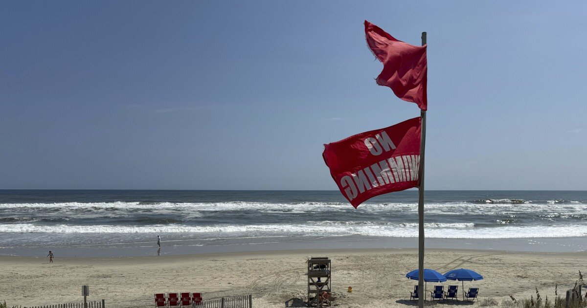
Officials Warn of Rip Currents and Beach Closures
Even in places where evacuation orders are not in effect, officials are advising the public to avoid the water. Up and down the Atlantic coast, including beaches in Georgia, the Carolinas, and portions of Virginia, dangerous rip currents are predicted.
Major portions of the Cape Hatteras National Seashore are among the beaches with completely closed access. Due to noncompliance with beach restrictions, coastal towns are getting ready for possible search and rescue operations, and lifeguards and emergency services are on alert.
Storm Surges, Flooding, and Travel Hazards Through the Week
Even though Hurricane Erin is predicted to stay offshore, flooding and storm surge might last for several tidal cycles due to its slow track and strong wind field. Residents are being advised by emergency management organizations in Virginia and North Carolina to safeguard their property, restrict travel in coastal areas, and heed local cautions.
With heavy rain expected to continue inland, communities in the Cape Fear River Basin, Albemarle Sound, and Pamlico Sound are at risk of flash flooding. Roadways near marshes and rivers may flood, putting additional pressure on emergency services.
N.C. DOT and Local Agencies on High Alert
The Department of Transportation in North Carolina has sent out teams to keep an eye on highways that are particularly susceptible, such as NC Highway 12, which has a history of significant damage during hurricanes. Ferries to Ocracoke Island have halted operation till further notice, and sandbags, flood barriers, and detour signage are being pre-staged in flood-prone areas.
Are you worried about evacuations or local storm safety in your area? Keep yourself informed by talking to your family about disaster preparedness and by paying attention to government alerts. VisitSaludaStandard-Sentinel.comdaily for the most recent weather reports impacting South Carolina and the entire East Coast.


