As Hurricane Erin moved near the mid-Atlantic coast and churned up dangerous waves that have shuttered beaches from the Carolinas to New York City, it started to strengthen once more on Wednesday, according to the Associated Press.
According to forecasters, the storm is expected to peak on Thursday and may re-intensify into a major hurricane.
Water started flowing onto North Carolina’s Outer Banks major highway and around a few stilted homes that were perilously perched above the beach, even though it is unlikely that Erin would make landfall along the East Coast before heading farther out to sea.
In addition to whipping up life-threatening rip currents from Florida to New England, authorities anticipate that the biggest swells during high tide may block off the Outer Banks villages and vacation houses.
Swimming was prohibited on New York City’s beaches on Wednesday and Thursday. Additionally, a few beaches in Delaware, Maryland, and New Jersey will be temporarily closed.
Later this week, Nantucket Island off Massachusetts may experience waves of over ten feet. However, the greatest danger persisted along the Outer Banks, where locals seemed unconcerned.
Jacob Throne, who lives on Hatteras Island and works for surf shops, said, “I don’t think it’s going to be that bad because I remember taking canoes out of my front yard to get to school.”
Erin was providing strong waves for the East Coast Surfing Championships and the kind of swells that many residents hadn’t seen in a long time, so surfers flocked to Virginia Beach’s waterfront.
Henry Thompson, a competitor in the open long board contest, claimed that we are infamous for lacking waves. Usually, a surf competition is canceled because there are no waves or it is held in extremely terrible waves.
When Erin blows straight off the Virginia coast on Thursday, the finals will come to a halt. However, Thompson stated that in the upcoming months, he anticipates more hurricanes and excellent surfing.
“We’re dreaming of hurricanes all year long, surfers,” he remarked.
Some swimmers were still disregarding the warnings even when beaches were closed elsewhere. A day after more than 80 people were rescued, rescuers on Tuesday rescued over a dozen people who were entangled in rip currents at Wrightsville Beach in North Carolina.
Even if someone believes they know how to handle a rip current, it’s still not safe, according to National Weather Service forecaster Bob Oravec.
He said, “You can be as aware as you like.” It may still be harmful.
North Carolina officials issued a warning on Wednesday that coastal flooding might occur in numerous oceanfront areas due to a mix of strong winds and enormous waves, which are predicted to be around 20 feet.
According to Will Ray, the state’s emergency management director, dangerous situations can be felt far from the eye, particularly with a system as big as Erin.
According to David Hallac, superintendent of the Cape Hatteras National Seashore, dozens of beach houses that are already dilapidated by long-term beach erosion and protective dunes may be in danger.
Two tropical disturbances east of Erin are also being monitored by the National Hurricane Center and have the potential to become named cyclones. Hurricanes known as Cape Verde storms are among the most destructive that threaten North America because of the warm ocean water that stretches for thousands of miles.
Despite orders to evacuate the Hatteras and Ocracoke Islands, the majority of inhabitants in the Outer Banks chose to remain.
“If it was coming straight at us, we probably wouldn’t stay,” said Rob Temple, who runs sailboat trips on Ocracoke.
His primary worries were whether the major route would be washed out and whether the narrow strip of low-lying barrier islands, which are becoming more and more susceptible to storm surges, would be closed off to tourists and delivery vehicles.
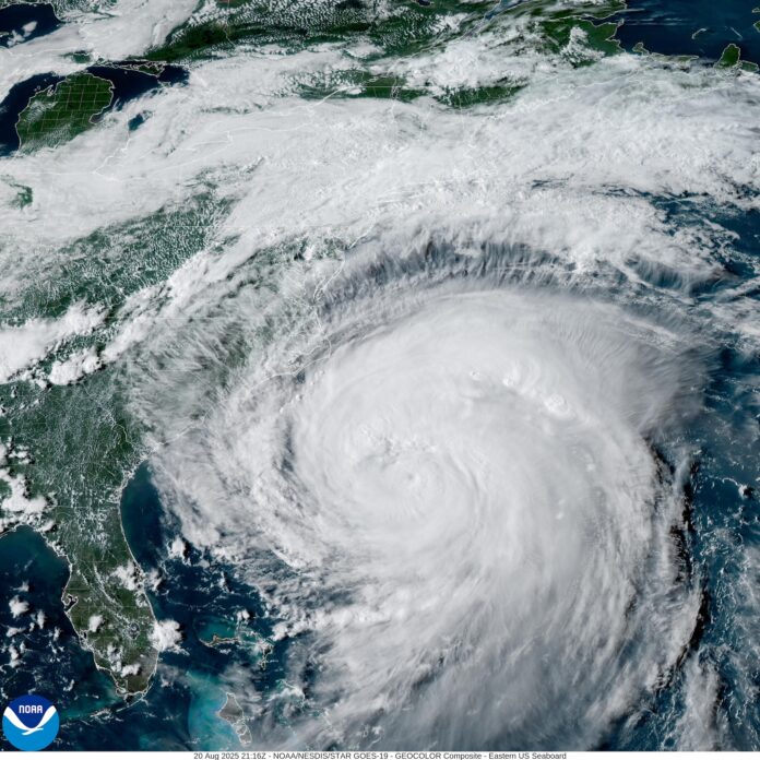
Erin’s tropical storm winds have expanded over 500 miles, or nearly the distance between New York City and Pittsburgh, making it an extremely large and potentially worrisome storm.
According to the National Hurricane Center, it was still a powerful Category 2 hurricane on Wednesday, with maximum sustained winds of about 110 mph. Erin was approximately 335 miles southeast of Cape Hatteras, North Carolina.
While residents and visitors in Bermuda were advised to avoid the water due to the possibility of strong seas until Friday, tropical storm warnings were issued for North Carolina and Virginia.
Warmer waters are making it considerably more likely for Atlantic hurricanes to quickly build into strong, destructive storms, according to climate experts.
By John Seewer and Allen G. Breed


