The South Carolina city of CharlestonAccording to WXII 12, forecasters are keeping an eye on two tropical waves in the Atlantic Ocean, one of which has a strong chance of developing into a tropical storm within the next day or two. Although the storm is presently expected to stay east of the United States, forecasters emphasize that it is crucial to keep an eye out for any changes in the pattern that would move it closer to the shores of North and South Carolina.
Two Tropical Systems Under Watch
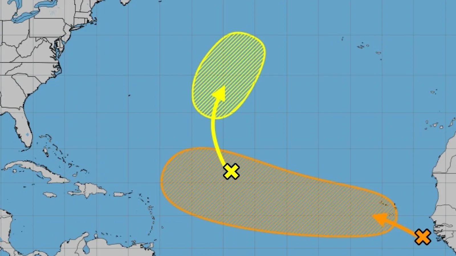
Invest 96-LandInvest 97-Las are the main regions of worry this week, according to meteorologists from the National Hurricane Center and the WXII 12 First Warning Weather Team.
-
Invest 96-L
Currently in the central Atlantic, this system is struggling to organize due to dry air. While some gradual development could occur early next week, the odds of significant strengthening remain low. -
Invest 97-L
Emerging from the
West African coast
over the weekend, this tropical wave is producing heavy rainfall over the
Cape Verde Islands
and is showing strong signs of development. Forecasters expect it to organize into a tropical depression or tropical storm likely named
Erin
in the next 24 48 hours.
Potential U.S. Impact
Later this week, Invest 97-L may intensify and even reach hurricane strength, according to forecast models. Any changes in the Atlantic weather pattern might move the system closer to the Carolinas, while longer-range forecasts suggest a potential turn toward Bermuda.
According to meteorologist Michelle Kennedy, this is the wave that we are now keeping the closest eye on. It can develop rapidly because of its structure, moisture content, and suitable wind conditions. It’s time to reassess your hurricane preparedness if you live on the East Coast.
2025 Atlantic Hurricane Season So Far
Four storms have already been named for the 2025 season:
-
Andrea
-
Barry
-
Chantal
brought deadly flash flooding to parts of
central North Carolina
, killing five people in early July. -
Dexter
formed in early August without causing major U.S. impacts.
Erin and Fernand are the next two names on the list.
Staying Prepared
Coastal residents should study evacuation routes, collect emergency supplies, and closely monitor official forecasts in the days ahead, according to hurricane specialists. As the systems advance, the National Hurricane Center will keep providing frequent updates.
Forecasters stress the need for attention even in years that begin relatively quiet, since tropical activity is predicted to increase in the second half of the hurricane season.
How do you feel about the storms that are forming? Have previous hurricanes altered your preparations? Join the discussion at SaludaStandard-Sentinel.com and leave your thoughts in the comments section.


